Projects
November 28, 2021 2023-11-29 9:38Projects

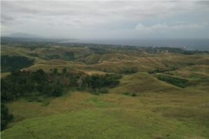
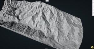
Guadalcanal’s Bloodiest Battle – Bloody Ridge Project
The Battle of Bloody Ridge, also known as the Battle of the Edson’s Ridge, was one of the most significant battles of the Guadalcanal Campaign during WWII. The battle was fought between Japanese and US ground forces on the 12th – 14th September 1942, and was part of an offensive by Japan to retake Henderson Airport, which had been taken by US Marines on the 7th of August. During a series of furious assaults Japanese forces came very close to breaking through the American lines, and the whole campaign hung in the balance. Guadalcanal proved to be the turning point in WWII for the Allied forces in the Pacific, and Bloody Ridge was the turning point of the Guadalcanal Campaign. Due to the significance of this site the Solomon Islands government declared Bloody Ridge a national Park in 2017. The Ministry of Culture and Tourism is currently planning to develop the Park into a world-class WWII visitor attraction. Project Snapshot Project Scope As part of Kahuto Pacific’s Impact Initiative we were able to assist the Solomon Islands Ministry of Tourism with one of their biggest hurdles – Mapping the Bloody Ridge for future developments and tourism attraction. Considering all the action that took place along with illegal settlers in the area, the safest and most efficient way to execute this would be a combination of Aerial Photogrammetry and LiDAR scan of the site. Solution The team recorded a couple of ground controls throughout the site to ensure that the aerial data captured is tying in accurately. This will aid in the Ministry of Tourisms planning phase of what should be a national attraction when complete. UAV operation was done at a safe distance ensuring safety and drone visibility. A Digital Surface Model (DSM), Digital Terrain Model (DTM) with contours were extracted from the aerial operation. The data delivered not only enabled the Ministry of Tourism to have better data to plan but also have a proper analysis of the battleground, identifying trails soldiers took, bunkers and foxholes used for protection, which ultimately be used as part of the museum. Challenges As the site had some illegal settlers who claimed property over the Ministry, it was important the team had proper security from the park rangers as well as representatives from the Ministry of Tourism to assist. Being 2 kilo-meters away from the airport we had to meticulously coordinate with the Air Traffic Control to confirm our windows of opportunity to fly. Results

Kinoya Waste Water Project
Project Snapshot Kahuto Pacific was contracted by Scope Pacific Engineers to carry out a LiDAR and Photogrammetry survey over the Kinoya Waste Water Treatment plant in Suva. As they were planning for infrastructure upgrade, they needed to clearly identify existing structures, pipelines, drainages, fence lines and roads to plan accordingly. Client – SCOPE Pacific Ltd Scope of Project The team were tasked to provide Digital Terrain Models, Orthomosaic maps and contours of the site. Also to help make life easier in identifying existing structures we proposed providing planimetrics/as-built drawings of the features. Solution Weather permitting, it was mostly a day’s work. Consist of 2 LiDAR and 2 Photogrammetry flights. From the data captured our team were able to easily identify features hidden under canopy such as drains and smaller road tracks. This enables the team to provide the client with accurate feature extractions. The team then provided CAD ready outputs to help engineers easily navigate with their software. Challenges As Suva is known for its wet and rainy days, this was mostly the challenge. As we needed a good dry and sunny day to fly and most importantly for the LiDAR data capture. Due to ongoing precipitation we needed to wait out for the surfaces to dry out at least before flying. Which in due time it did. Results
Uncovering WWII Heroes with Drone LiDAR & Magnetometry
The team equipped with the DJI M300 and a Livox R2A (LiDAR) Sensor faced a unique challenge. We needed to fly at a low altitude to produce the most accurate results. This low-altitude, high resolution approach was essential for penetrating the dense jungle. The combination of the DJI M300’s precision flight capabilities and the LiDAR sensor’s ability to see between the thick foliage made the duo the ideal choice for the mission.
LiDAR Survey of 2500 acre Gold Project
The client needed accurate contours and DEM (Digital Elevation Model) for the challenging 2500 acre site. Mine engineers and planners needed an accurate baseline dataset to begin planning and design of key mine infrastructure.
Drone LiDAR Flood Mapping Fiji
Kahuto Pacific on behalf of Pacific Community-SPC captured an aerial LiDAR survey to produce a Digital Elevation Model (DEM) for flood modeling of the Penang River catchment (Rakiraki), Fiji.